Brook Road Sweet Shop

Micky and Albert Mancey's sweet shop, 38 Brook Road
Micky and Albert Mancey’s sweet shop, 38 Brook Road

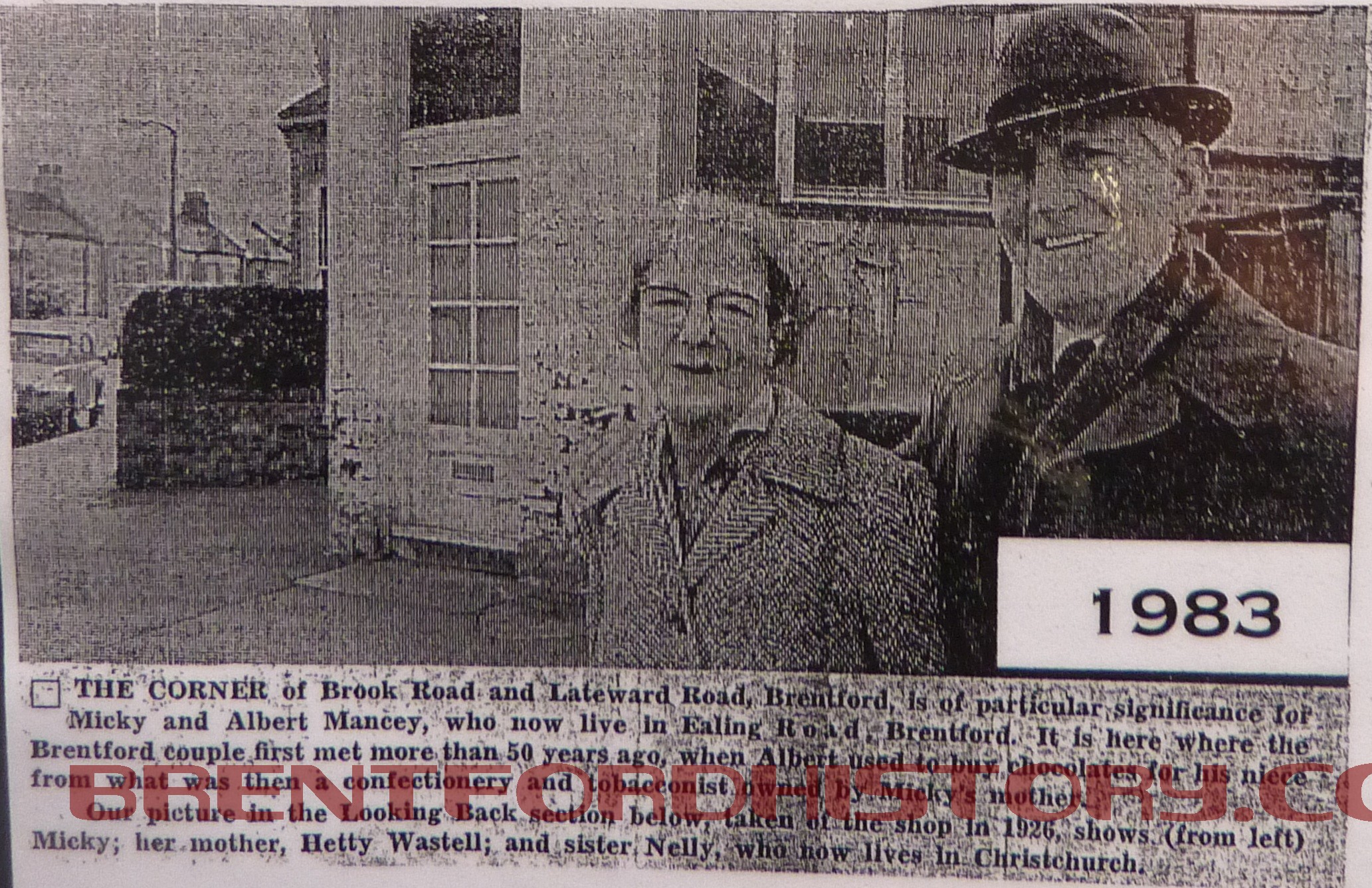
“The corner of Brook Road and Lateward Road, Brentford, is of particular significance for Micky and Albert Mancey, who now live in Ealing Road, Brentford. It is here where the Brentford couple first met more than 50 years ago, when Albert used to buy chocolates for his niece from what was then a confectionery and tobacconist owned by Micky’s mother.

“Our picture in the Looking Back section below, taken of the shop in 1926, shows (from left) Micky; her mother, Hetty Wastell; and sister Nelly, who now lives in Christchurch. Continue reading “Brook Road Sweet Shop”

Daubney’s Greengrocers, 45 Brook Road

Daubney's Greengrocers, 45 Brook Road

Long established family shopkeepers are difficult to find in towns today. But in Brentford, if you wander around the Victorian terraced back streets, a small handful of them still open their doors for business every day – a tradition that dates back generations.

Greengrocer, Bill Daubney, aged 65, is one whose name has been above his shop in Brook Road South for the last 46 years, and could conjure up an entire panorama of Brentford as fresh as his vegetables.

Bill produced two oval gilt framed portraits of his parents, “I only found them the other day” he said. He recalled that the pictures cost 24 shillings each. “My mother paid 6d a week for them” he said.

Bill, his parents and seven brothers and sisters , lived in a small cottage in Albany Road, one street away from where he works now.

His father was a greengrocer, and his grandfather worked in the fish trade. Both were born and bred in Brentford. Continue reading “Daubney’s Greengrocers, 45 Brook Road”

Brook Road South – the War Years

There has been some publicity recently about a website showing incidents of bombing all over the country during World War 2.

The Local Studies Collection in Chiswick Library holds the records of all the local ‘incidents’ which suggest that 26 people were killed in Brentford due to the bombing, 63 were seriously injured and 149 suffered minor injuries.

The ‘incident’ that caused the most damage in Brook Road happened at 01.40 on September 29th 1940 and was one of 29 occurrences in the borough that night. Continue reading “Brook Road South – the War Years”

Brook Road South – Early 20th Century

By the early 20th century the orchards had gone and the road was built up on both sides. There were shops on the corners of the side roads and the consecutive numbering had been changed to odds and evens as it is nowadays.

The 1901/2 street directory shows the east side of the road at number
1 Frank Jarvis was a baker,
43 John Edward Ross was a hairdresser,
45 Robert Dixon greengrocer,
57 Thomas Everdene was a grocer,
The Griffin had been there since 1884 and Henry A Compton was the landlord.
59 Frederick Luffrum was a greengrocer. Continue reading “Brook Road South – Early 20th Century”

Brook Road South – Growth of Housing

The first houses to be built after the land sale in 1872 were on the west side running north from Albany Road. They were numbered consecutively with numbers 8, 9, 10 and 11 north of Grosvenor Road which ran down hill to towards the recreation ground. They were called Grosvenor Terrace and are now numbers 14, 16, 18 and 20 Brook Road South.

The builder, Henry Spicer lived at the Lord Nelson PH in Enfield Road was brought to account in 1883 for allowing these 4 houses to be occupied without giving notice to the Sanitary Authority. Continue reading “Brook Road South – Growth of Housing”

Brook Road South – Brook House

From Brook House down to Albany Road

In 1872 there was a major sale of the cultivated land between Albany Road and the railway.

The piece of land that is now the south side of the football ground was bought for £580 by John Carpenter who lived at Brook House on the north west corner. This was Lot 19 and described as ‘enclosed on all sides nearly with substantial fruit walls, well stocked with fine standard and other fruit trees, also four division and two cross walls all well clothed  with choice fruit trees, a packing shed and a well of water’. Brook House looks to have been quite a large house with a formal garden but there don’t seem to be any pictures of it. (Unless any readers can provide one!)

Mr Carpenter had been born in Sussex in 1814 and by the time of the 1841 census had a business as an ‘oilman’ at 52, High Street. He was married with 5 children. This business was described as ‘oil and colour trade’ by 1861 and he was also shown in directories as a ‘rag and general merchant’. Continue reading “Brook Road South – Brook House”

Brook Road South – Market Gardening

In 1837, a few months after Victoria became Queen,  a piece of land between Brook Lane and Drum Lane (now Ealing Road) was for sale. It was described as 4 acres of partly walled Market Garden Ground and it contained ‘Three Respectable, residences, a cottage and numerous outbuildings’.

The map with the notice of sale shows that the buildings were near the present site of the Griffin. There’s a bend in Brook Lane to the left which is still there and the brook runs as an open stream along the west side of the road. Continue reading “Brook Road South – Market Gardening”

Brook Road South – The Brook

1841 Tithe Map of Brentford

The Tithe Map of Brentford in 1841 shows that the area of the town west of Drum Lane (now Ealing Road) was tightly packed buildings between the High Street and Albany Road with open ground beyond. Running north to south is a blue line marking the route of the brook. Parallel with the water course is a narrow road and at a sharp bend there are four cottages later called Brook Terrace. Continue reading “Brook Road South – The Brook”